 |
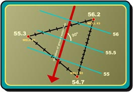
A water-level contour map is a common tool used by a hydrogeologist to indicate groundwater flow directions and to test the continuum approach.
Todd (1959) asserts that under steady state conditions, flow lines lie perpendicular to water table contours. From field measurements of static water levels in wells, a water level contour map can be constructed. Anomalously high or low water levels or jagged or discontinuous contours may be evidence that the continuum approach is not legitimate. Water flow directions will aid in the delineation of the source water protection area.