SOIL EROSION AND
SEDIMENTATION CONTROL
MANUAL FOR AGRICULTURE
BUREAU OF LAND AND WATER CONSERVATION
COMMONWEALTH OF PENNSYLVANIA
Tom Ridge, Governor
DEPARTMENT OF ENVIRONMENTAL
PROTECTION
James M. Seif, Secretary
DEPARTMENT OF ENVIRONMENTAL PROTECTION
Bureau of Land and Water Conservation
Division of Stormwater Management and Sediment Control
Document Number: 392-2134-011
Title: Soil Erosion and Sedimentation Control Manual for Agriculture
Authority: Pennsylvania’s Clean Streams Law(P.L. 1987, No. 394)(35 P.S. §§ 691.5 and 691.402) and regulations at 25 Pa. Code Chapter 102
Effective Date: DRAFT, October 21, 1996
Policy: It is the department’s policy to provide those involved in earth disturbance activities with guidance on what must be done to comply with Chapter 102, Erosion Control regulations.
Purpose: This guidance will define a conservation plan that will meet the requirements of Chapter 102, Erosion Control regulations, for farming operations.
Applicability: This guidance applies to all farms that include plowing and tilling as part of their operation.
Disclaimer: The policies and procedures outlined in this guidance are intended to supplement existing requirements. Nothing in the policies or procedures shall affect regulatory requirements.
The policies and procedures herein are not an adjudication or a regulation. There is no intent on the part of DEP to give the rules in these policies that weight or deference. This document establishes the frame work within which DEP will exercise its administrative discretion in the future. DEP reserves the right to deviate from this policy statement if circumstances warrant.
Page Length: 19 pages
Location: Volume 1, Tab B
Note: The drawings that would appear on Page 16 is not available on the WEB site.
SOIL EROSION AND SEDIMENTATION CONTROL MANUAL FOR AGRICULTURE
PART I - INTRODUCTION.................................................................................................3
PART II - GENERAL INFORMATION..................................................................................4
OPERATIONS CONSIDERED TO BE AGRICULTURAL ACTIVITIES....................................4
PLAN REQUIREMENTS FOR AGRICULTURAL ACTIVITIES...............................................4
PART III - CONSERVATION PLAN CONTENT....................................................................6
GENERAL INFORMATION................................................................................................6
PLAN CONTENT..............................................................................................................6
Conservation Plan Map..................................................................................................6
Soils Map.......................................................................................................................7
Conservation Plan Narrative..........................................................................................7
Other Information to be Added to the Conservation Plan..............................................7
PART IV - EROSION AND SEDIMENTATION BEST MANAGEMENT PRACTICES APPLICABLE TO AGRICULTURAL ACTIVITIES..........................................................................................7
Partial listing and brief description of cropland, grassland, woodland , structural, and special treatment best management measures applicable to agricultural activities.....7
APPENDICES
Definitions...................................................................................................................11
Listing of Conservation Districts Addresses and Phone
Numbers................................13
Other Sources of
Assistance.......................................................................................15
Sample Conservation
Plan.........................................................................................16
PART I - INTRODUCTION
Soil is one of the vital natural resources utilized by farmers to produce the food and fiber needed by our nation. The processes used to produce crops involves earth disturbance to varying degrees depending on the type of tillage, planting techniques, and cultivation. As with any type of earth disturbance, crop production usually increases the potential for accelerated erosion and sedimentation to occur.
To help address these concerns, conservation districts were formed to help farmers plan, develop, and implement voluntary soil conservation programs on their land. The locally administered conservation districts have made impressive gains in voluntary soil conservation programs. However, soil eroding from our farms, rural, and suburban areas continues to be the single greatest pollutant by volume to the waters of the Commonwealth.
According to Water Quality Indicators Guide, "In the United States today, watersheds are adversely affected by agriculturally related pollutants. Sediment, probably the most common and easily recognized of the nonpoint source pollutants ranks first in quantity among pollutants contributed by agriculture to receiving waters. Cropland erosion accounts for 40 to 50 percent of the approximately 1.5 billion tons of sediment that reaches the Nation’s waterways each year. Streambank erosion accounts for another 26 percent. The amount of sediment eroding from agricultural areas is directly related to land use - the more intensive the use, the greater the erosion. For example, in a given locality more sediment erodes from row crop fields than from pastures or woodlands. Sediment lost from agricultural sites varies significantly with the presence or absence of management practices. Considerably more sediment is lost from agricultural land in row crops without management practices than in row crops with management practices. The least amount of sediment is lost from agricultural lands that have conservation cropping systems, i.e., practices such as cover crops and conservation tillage."
To further address these concerns, Pennsylvania’s Chapter 102 Erosion Control Rules and Regulations were adopted by the Environmental Quality Board in 1972 . Section 102.4, discusses responsibility for erosion and sedimentation control for agricultural tilling and plowing. Section 102.31 exempts plowing and tilling for agricultural purposes from permit requirements, but notes that the exemption from a permit does not provide an exemption from other provisions of Chapter 102. The effective date of the regulations for agricultural activities was July 1, 1977. Section 316 of the Clean Streams Law, Act 222, of 1970, says in part "..If the department finds that the pollution or danger of pollution results from an act of God in the form of sediment from land for which a complete conservation plan has been developed...and the plan has been fully implemented and maintained, the landowner shall be excluded from the penalties of this act.". This is a recognition that cropland farming involves earth disturbance, and notes the positive impact of having a conservation plan prepared and implemented to address erosion and sedimentation concerns on cropland.
A conservation plan includes best management practices to address erosion and sedimentation control and protection of the soil resource. In the absence of a complete conservation plan, an erosion and sedimentation control plan consisting of appropriate numbers and locations of sediment removal best management practices, must be developed, installed and maintained.
A Conservation Catalog for Pennsylvania, available from local County Conservation Districts features 19 soil-savings practices. The catalog is a cooperative effort of the USDA, Natural Resources Conservation Service, Pennsylvania Department of Environmental Protection, Bureau of Land and Water Conservation, and the Somerset and Westmoreland County Conservation Districts. It explains how each practice works, gives tips on installing or managing practices, and suggests how the practices may be combined with others for soil and water conservation systems.
This manual provides guidance regarding the erosion and sedimentation control responsibilities of farmers under Pennsylvania’s rules and regulations. Guidance for nutrient management responsibilities is found in the rules and regulations developed for Act 6, the Nutrient Management Act, and is not included in this manual.
PART II - GENERAL INFORMATION
OPERATIONS CONSIDERED TO BE AGRICULTURAL ACTIVITIES
The customary and generally accepted activities, practices and procedures that farmers adopt, use or engage in year after year in the:
Production of vegetables, fruits, seeds, mushrooms, nuts, and nursery crops for sale.
Production of poultry, livestock, and their products for sale.
Production of field crops, hay, or pasture.
Production of sod to be removed and planted elsewhere.
Any lands or portions of State Game lands leased for agricultural tilling and plowing, or lands used for crop and livestock research areas are considered agricultural activities and are subject to the requirements of Chapter 102.
PLAN REQUIREMENTS FOR AGRICULTURAL ACTIVITIES
GENERAL INFORMATION
In order to meet the requirements of Chapter 102, farmers have two choices. They may keep their soil in place by preventing accelerated erosion or they may capture soils that have eroded at an accelerated rate to prevent them from polluting the waters of the Commonwealth. To keep soil in place, one option is to develop, implement and maintain a conservation plan for the lands on their crop producing fields. To capture soils that have eroded at an accelerated rate, farmers may design, implement and maintain an erosion and sedimentation control plan consisting of appropriate numbers and locations of sediment removal best management practices. Such a plan, while meeting the requirements of Chapter 102, does nothing to maintain the soil resource base that is required for a successful farm to remain successful over time. The requirements for each of these plans is detailed below and in PART III of this manual.
New building construction, road construction, etc. requires an erosion and sedimentation control plan to be prepared and implemented. Typical elements of an erosion and sedimentation control plan for these types of activities may include temporary diversions to channel upslope runoff around the disturbed site, and sediment removal devices (silt fence, sediment trap or basin) to treat the sediment laden runoff downslope of the site
A conservation plan or an erosion and sedimentation control plan is prepared and implemented for all operations considered to be agricultural activities that involve earth disturbance and woodlots (during timber harvesting operations) on a farm. The plan should be available at all times and updated as needed to guide the responsible person or persons for the overall operations of the farm. Elements of the conservation plan include appropriate management and/or structural best management practices mentioned in Part IV of this manual.
Installation of conservation practices which disturb the land surface, such as diversions, waterways, etc. is also required to have erosion and sedimentation control measures designed and installed as part of the conservation practice installation. Details and descriptions for erosion and sedimentation control measures are found in the Erosion and Sediment Pollution Control Program Manual.
A conservation plan or an erosion and sedimentation control plan reflects the current agricultural operation. It is the responsibility of the landowner or user to keep the plan current. For example, if new fields are brought into production, the conservation plan or an erosion and sedimentation control plan is revised to include the new fields. Similarly if fields that were formerly permanent hay are converted to row crops, the conservation plan or an erosion and sedimentation control plan for those fields will need to be revised. Revisions to the conservation plan or erosion and sedimentation control plan must then be implemented.
How can you tell if you need to revise your plan, or if your plan is working? Examine the condition of all waterways. Examine the condition of any watercourse flowing through or adjacent to your property. Sediment accumulation in the form of deltas at stormwater discharge points, sediment covering the stream bottom and aquatic vegetation may indicate accelerated erosion and resulting sedimentation from your property. Observe your crop fields during a rainstorm. Gullies forming and soil washing away from your crop fields are indicators that your conservation plan may not be adequate. Very muddy water running into watercourses adjacent to your crop fields are also an indicator of an inadequate conservation plan. Most practices included in a conservation plan are designed for a 10 to 25 year frequency storm. Some damage to practices can be expected from more intense storms; likewise muddy water discharges may occur from these storms even though an adequate conservation plan has been developed and implemented.
What do you do now? A farmer may receive assistance in preparing or revising a conservation plan by becoming a conservation district cooperator. The conservation district requests a representative of the Natural Resources Conservation Service, USDA, to provide technical assistance in preparing a conservation plan to meet the needs of the landowner and the standards of the Pennsylvania Soil and Water Conservation Technical Guide. Private consultants, Conservation District staff, and Certified Crop Advisers may also assist farmers to develop conservation plans. Call your local conservation district for further instructions.
The plan covers all agricultural activities involving earth disturbance and is approved by the conservation district. The landowner is responsible for the implementation of the plan. Conservation plans developed by landowners and consultants shall be submitted to the conservation district for review and approval and maintained for reference purposes in the conservation district files .
PART III - CONSERVATION PLAN CONTENT
AGRICULTURAL EROSION & SEDIMENTATION CONTROL PLAN CONTENT
CONSERVATION PLAN CONTENT
A conservation plan shall be prepared by a person trained and experienced in erosion and sedimentation control techniques to meet the requirements of the Chapter 102 regulations, and includes the following:
1. Sufficient management and/or structural best management practices to minimize accelerated erosion, prevent sediment pollution to the waters of the Commonwealth, and maintain the resource base. Generally this will require a conservation plan that meets the soil loss tolerance, commonly called "T". Soil loss tolerances denote the maximum level of soil erosion that allows high levels of sustainable economic crop productivity. The Revised Universal Soil Loss Equation (RUSLE) is a management tool used to estimate soil losses by sheet and rill erosion from rainfall. The purpose of the RUSLE is to predict long-term average soil losses in runoff from specific field areas under specified cropping and management systems. The effectiveness of a particular land treatment alternative can be evaluated when the predicted soil loss for that treatment is compared with the "T" for the specific soils involved. Additional information about "T", and RUSLE can be found in the Pennsylvania Soil and Water Conservation Technical Guide
2. Computations to show that the flow velocity for storm water runoff from the farm for a 10-year frequency storm (or a discharge of 2.75 cubic feet per second per acre drained) will not cause erosion in on-farm or off-farm waterways or channels. See Chapter 4 of Pennsylvania Erosion and Sediment Pollution Control Program Manual or Chapter 2 of the NRCS Engineering Field Handbook for additional information about these computations.
AGRICULTURAL EROSION & SEDIMENTATION CONTROL PLAN CONTENT
An agricultural erosion and sedimentation control plan should include best management practices to remove sediment from runoff where runoff from tilled areas flows directly into perennial streams. The requirements for best management practices are found in the Pennsylvania Soil and Water Conservation Technical Guide and in Chapter 4 of Pennsylvania Erosion and Sediment Pollution Control Program Manual.
PLAN ELEMENTS
A conservation plan consists of a conservation plan map, a soils map, and a narrative. An erosion and sedimentation control plan also contains these same elements. A sample conservation plan is included in the Appendices.
Conservation Plan Map - This map shows the farm boundaries, field boundaries, use of each field, acres in each field, permanent conservation measures installed and/or planned, and the scale of the map. Usually a scale between 1"=400’ and 1"=1320’ is sufficient as long as the intensity of the farm operation can be clearly shown. A title block on the conservation plan map includes the name of the farmer, the location of the farm (municipality and county), the acres of the farm, the date the map was prepared, the name of the person who prepared the map, and the scale of the map. An aerial photograph may be used as a map. The map includes a legend that explains all of the symbols used.
Soils Map - The soils map indicates the kinds and boundaries of soils. A title block on the soils map includes the name of the farmer, the location of the farm (municipality and county), the source of the soil survey data, the acres of the farm, and the scale of the map. A soil legend accompanying the soils map provides an explanation of all soil symbols shown on the map. A description of the mapping units includes the soil parent material, slope, texture, drainage characteristics, available moisture, depth, erosion hazard, and fertility characteristic
Conservation Plan Narrative - The narrative includes names, units and amounts, and locations of each of the conservation practices installed or to be installed. Implementation of the conservation plan means that the various measures be installed in a timely fashion. Certain measures are installed before others. For example a waterway may serve as an outlet for diversions. Therefore, the waterway is installed, stabilized and operating before the diversions are constructed. The year of installation for practices already installed; and a schedule (month and year) for practices not yet installed is included in the plan.
Continual management and maintenance of best management practices is essential for proper functioning. Structural practices are designed for a specific storm frequency and may suffer damage when larger storms occur. After such storms, practices are inspected and damage is repaired so they continue to function as designed and installed. Structural practices which require earth moving and stabilization should be frequently checked to assure that vegetation and other types of stabilization are adequate to protect the structure and to assure that it will continue to function properly. Reseeding and/or reshaping may be needed periodically, especially after major rainfall events. Vegetated practices should also receive adequate lime and fertilizer to assure that the vegetative cover is adequate for the intended purpose. After major rainfall events, they should be inspected for any type of damage or deterioration. Trees and brush should not be allowed to grow on berms, dams, or other structural embankments.
Other best management practices such as stripcropping, contour farming and grass buffers require attention annually to assure the boundaries are maintained and adequate vegetation is maintained. Practices which are performed annually such as cover crops, conservation tillage, crop residue management and crop rotations, must be carried out according to the conservation plan. These practices require detailed attention to assure they are carried out when and to the extent specified. Tillage and residue management are two specific examples that require this attention.
Other Information to be Added to the Conservation Plan - Prior to the installation of structural conservation practices, detailed designs and construction drawings for the practices are prepared. Details of interim erosion control measures used during the installation of structural measures are included in the construction drawings.
An erosion and sedimentation control plan contains the same elements as a conservation plan. The Plan map would be similar to the one described for a conservation plan, except that the only practices to be shown would be the sediment removal best management practices. All other elements of the map would be as described above for a conservation plan map. The Soils Map would be identical to the one described above for a conservation plan. The Narrative would contain the details required for the construction of best management practices for sediment removal. It would also explain how the sediment removal best management practices would be maintained; where and how the captured sediment would be disposed of, and how it would be stabilized to prevent it’s migration into the waters of the Commonwealth. Other Information would be similar to that described above for a conservation plan.
Part IV - EROSION AND SEDIMENTATION CONTROL BEST MANAGEMENT PRACTICES APPLICABLE TO AGRICULTURAL ACTIVITIES
The following list of conservation practices are some of the more common best management practices used to control erosion and sedimentation on farmland. Prevention of erosion is more desirable and effective than treatment of runoff which contains heavy concentrations of sediment. Diversion of surface water away from plowed and tilled areas and maintenance of cover on cropland through use of conservation tillage systems can be effective ways of preventing erosion.
Access Road - A travelway constructed as part of a conservation plan. It’s purpose is to provide a fixed route for travel for moving livestock, produce, equipment, and supplies. It may also be used to provide access for proper operation, maintenance and management of conservation enterprises and conservation farming systems while controlling runoff to prevent erosion and maintain or improve water quality.
Barnyard Runoff Control - The collection and reduction of runoff water and agricultural wastes from barnyards, feedlots and other outdoor livestock concentration areas for storage or treatment to improve water quality.
Channel Vegetation - Establishing and maintaining adequate plants on channel banks, beds, berms, spoil and associated areas. This is done to stabilize channel banks and adjacent areas for temporary and/or permanent protection and reduce erosion and sedimentation.
Conservation Cover - Establishing and maintaining perennial vegetative cover to protect soil and water resources on land retired from agricultural production. This will help reduce soil erosion and sedimentation, thus protecting water quality and creating or enhancing wildlife habitat.
Conservation Cropping Sequence - An adapted sequence of crops designed to provide adequate organic residue for maintenance or improvement of soil tilth. By utilizing this practice, one will help improve the physical, chemical and biological soil conditions, maintain or improve soil productivity, protect the soil against erosion and overload runoff, and maintain or improve water quality.
Conservation Tillage System - Any tillage and planting system in which at least 30 percent of the soil surface is covered by plant residue after planting to reduce soil erosion by water during the critical erosion period.
Contour Farming - Farming sloping land in such a way that preparing land, planting, and cultivating are done on the contour (this includes following established grades of terraces or diversions). This practice may be applied to reduce sheet and rill erosion, to manage runoff to increase plant available moisture and to improve surface water quality by reducing siltation.
Cover and Green Manure Crop - A crop of close-growing grasses, legumes or small grain grown primarily for seasonal protection and soil improvement. It usually is grown for one year or less to control erosion during periods when major crops do not furnish adequate cover.
Critical Area Planting - Planting vegetation, such as trees, shrubs, vines, grasses or legumes on highly erodible or critically eroding areas (does not include tree planting mainly for wood products).
Crop Residue Use - Using plant residues to protect cultivated fields during critical erosion periods. This practice maybe planned to reduce soil loss during critical periods, to conserve soil moisture, to maintain or improve soil tilth, to reduce fluctuations in soil temperature, and to provide food and cover for wildlife.
Cross Slope Farming - Farming sloping land in such a way that tillage, planting and harvesting are done perpendicular to the predominant slope, but not necessarily on the contour. This practice is used to reduce sheet and rill erosion and improve surface water quality by reducing siltation.
Diversion - A channel constructed across the slope with a supporting ridge on the lower side. This is done to divert excess water from one area for use or safe disposal in other areas. Establishment and maintenance of permanent stabilization (usually grass) is required.
Field Border - A band of grass or legume at the edge of a field used in place of end rows. This practice is used to control erosion and to protect edges of fields that are used as turnrows or travel lanes.
Filter Strip - A strip or area of vegetation for removing sediment, organic matter and other pollutants from runoff. This is done via several different processes such as filtration, infiltration, absorption, adsorption, decomposition and volatilization.
Forest Land Erosion Control System - Application of one or more erosion control measures on forest land. Erosion control system includes the use of erosion control structures, conservation plants and cultural practices for the control of sheet and rill erosion, gully formation and mass soil movement
Grade Stabilization Structure - A structure to control the grade and head cutting in natural or artificial channels. Waterways need stabilizing structures if slopes are so steep that the velocity of runoff exceeds the limit of protection that vegetation alone gives. Energy dissipaters may be required at the outlets of the structures. The structures should be designed and constructed to provide permanent stabilization. Types of grade stabilization structures include straight drop spillways, box inlet drop spillways, drop boxes, concrete chute spillways and drop inlet spillways
Grassed Waterway - A natural or constructed channel that is shaped or graded to required dimensions and established in permanent or continuous vegetation for the stable conveyance of runoff. The purpose of this structure is to convey runoff from terraces, diversions or other water concentrations without causing erosion of flooding and to improve water quality. Where existing vegetative cover is inadequate to protect the natural waterways or swales from erosion resulting from additional water volumes and velocities, the channels can be improved by grading, reshaping, fertilizing and revegetating. Man-made outlets should be designed to provide adequate capacities. They should be proportioned to carry runoff at safe velocities.
Heavy Use Area Protection - Protecting against erosion on heavily used areas by establishing vegetative cover, by surfacing with suitable materials, or by installing needed structures.
Lined Waterway or Outlet - A waterway or outlet with an erosion-resistant lining of concrete, stone or other permanent material. The lined section extends up the side slopes to the designed depth of flow. The earth above the permanent lining may be vegetated or otherwise protected. It’s purpose is to provide for the safe disposal of runoff from other concentrations of flow without damage by erosion or flooding, where unlined or grassed waterways would be inadequate
Mulching - Applying plant residues or other suitable materials, not produced on the site, to the surface of the soil. This application will help conserve moisture; prevent surface compaction or crusting; reduce runoff and erosion; control weeds; and help establish plant cover.
Pasture and Hayland Management - Proper treatment and use of pastureland or hayland. By use of a proper management system, one can prolong the life of desirable forage species; maintain or improve the quality and quantity of forage; and protect the soil and reduce water loss.
Pasture and Hayland Planting - Establishing and reestablishing long-term stands of adapted species of perennial, biennial or reseeding forage plants. This is done to reduce erosion, to produce high-quality forage and to adjust land use.
Roof Runoff Management - A facility for collecting, controlling and disposing of runoff water from roofs. This helps to prevent runoff water from flowing across concentrated waste areas, barnyards, roads and alleys, and to reduce pollution and erosion, improve water quality, prevent flooding, improve drainage, and protect the environment.
Runoff Management System - A system for controlling excess runoff caused by construction operations at development sites, changes in land use, or other land disturbances. This is done to minimize such undesirable effects as flooding, erosion, sedimentation and to maintain or improve water quality.
Sediment Basin - A basin constructed to collect and store sediment and debris. This practice applies where conditions preclude the installation of erosion control measures to keep soil in place or where a sediment basin offers the most practical solution to containing erosion.
Stripcropping:
Contour - Growing crops in a systematic arrangement of strips or bands on the contour to reduce water erosion. The crops are arranged so that a strip of grass or close-growing crop is alternated with a strip of clean-tilled crop or fallow or a strip of grass is alternated with a close-growing crop. This done to reduce sheet and rill erosion, manage runoff to increase plant available moisture and improve surface water quality by reducing siltation.
Field - Growing crops in a systematic arrangement of strips or bands across the general slope (not on the contour) to reduce water erosion. The crops are arranged so that a strip of grass or a close-growing crop is alternated with a clean-tilled crop or fallow. This practice will reduce sheet and rill erosion and improve surface water quality by reducing siltation.
Terrace - An earth embankment or a ridge and channel constructed across the slope at a suitable spacing and with an acceptable grade. They are built to reduce erosion, reduce sediment content in runoff water, intercept and conduct surface runoff of a nonerosive velocity to a stable outlet, prevent gully development, improve farmability and reduce flooding, and increase soil moisture
For more complete information concerning design, construction, and maintenance of the preceding best management practices, refer to the current edition of the Pennsylvania Soil and Water Conservation Technical Guide prepared by the Natural Resources Conservation Service.
DEFINITIONS
Accelerated Erosion The removal of the surface of the land through the combined action of man’s activities and the natural processes, at a rate greater than would occur because of the natural process alone.
Agricultural operations - The management and use of farming resources for the production of crops, livestock, or poultry
Best Management Practice (BMP) - Management activities, facilities, measures, or procedures used to minimize pollution to waters of the Commonwealth.
Commission - The State Conservation Commission established by the Act of May 15, 1945 (P.L. 547, No. 217), 3 P.S. §§849-864, known as the Conservation District Law, and as amended by Act 18 of 1995.
Concentrated water flow areas - Those natural or manmade areas where storm water runoff is channeled and conveyed directly to a surface body of water. Concentrated water flow areas include, but are not limited to, ditches, waterways, gullies, and swales.
Conservation Plan A plan that identifies Best Managaement Practices for agricultural plowing and tilling. A conservation plan which includes location, land use, tillage systems, and conservation treatment measures and schedules is considered to be an erosion and sediment pollution control plan.
Erosion - The natural process by which the surface of the land is worn away by the action of water, wind, or chemical action.
Farm - The land area devoted to an agricultural use, excluding greenhouses, mushroom production, or confined livestock or poultry operations
Implemented (also implementation) - Adequately applied or having a written schedule for implementation.
Natural Resources Conservation Service (NRCS) - The Natural Resources Conservation Service of the United States Department of Agriculture, formerly know as the Soil Conservation Service.
Pennsylvania Agronomy Guide - The quick reference book published by the Cooperative Extension as a practical guide to grain and forage production, soil fertility management, pest management, and erosion control, with special reference to Pennsylvania conditions.
Pennsylvania Erosion and Sediment Pollution Control Program Manual - A primary reference document published by the Pennsylvania Department of Environmental Resources, Bureau of Land and Water Conservation, which is used by technically trained persons to prepare erosion and sedimentation control plans for earth moving activities.
Pennsylvania Soil and Water Conservation Technical Guide - A primary reference document published by the United States Department of Agriculture’s NRCS, which is used by technically trained persons to plan and apply BMPs.
Plowing and tilling - The disturbance of the land surface for an agricultural activity
Sediment - Soils or other surface materials transported by surface water as a product of erosion.
Sedimentation - The process by which sediment is deposited on stream bottoms.
Stormwater - drainage runoff from the surface of the land resulting from rain, or snow or ice melt.
Tilled area - Farm fields used for crop production that have less than 30% crop residue cover during times of crop establishment, and less than 50% cover during other times of the year. A cover crop may be used instead of crop residue.
LISTING OF CONSERVATION DISTRICTS’ ADDRESSES AND PHONE NUMBERS
County Street Address City Phone Number
Adams 57 N. Fifth Street Gettysburg, PA 17325 717-334-0636
Allegheny 875 Greentree Rd ,Rm208 Acacia Bldg Pittsburgh, PA 15220 412-921-1999
Armstrong Armsdale Admin Bldg, RR8 Box 294 Kittanning, PA 16201 412-548-3425 /3428
Beaver 1000 Third St Ste202 Beaver, PA 15009-2026 412-774-7090
Bedford Fairlawn Ct Ste 4, 702 W Pitt St Bedford, PA 15522 814-623-6706 /8099
Berks P O Box 520 Ag Ctr Leesport, PA 19533 610-372-4657
Blair 1407 Blair Street Hollidaysburg, PA 16648 814-696-0877
Bradford RR5 Box 5030C, Stoll Nat Res Ctr Towanda, PA 18848 717-265-5539
Bucks 924 Town Center New Britain, PA 18901 215-345-7577
Butler 122 McCune Drive Butler, PA 16001-6501 412-284-5270/5271
Cambria P O Box 187 Ebensburg, PA 15931 814-472-2120
Cameron 416 N. Broad St. Emporium, PA 15834 814-486-3350
Carbon 92 Blakeslee Blvd,E. Lehighton, PA 18235 610-377-4894
Centre 414 Holmes Ave Ste4 Bellefonte, PA 16823 814-355-6817/6818
Chester Gov Serv Ctr Ste395,601 Westtown Rd West Chester, PA 19382 610-696-5126
Clarion RR3 Box 265 Clarion, PA 16214 814-226-4070
Clearfield 650 Leonard Street Clearfield, PA 16830 814-765-2629
Clinton 2 State Route 150 Mill Hall, PA 17751 717-726-3798
Columbia 1127a Old Berwick Rd Bloomsburg, PA 17815 717-784-1310
Crawford 1012 Water Street Ste 18 Meadville, PA 16335 814-724-1793
Cumberland 43 Brookwood Ave Ste4 Carlisle, PA 17013 717-249-8632
Dauphin 1451 Peters Mtn Rd Dauphin, PA 17018 717-921-8100
Delaware 1521 N Providence Rd Media, PA 19063 610-892-9484
Elk Courthouse, P O Box 448 Ridgway, PA 15853 814-776-5373
Erie 12723 Rte 19,P O Box 801 Waterford, PA 16441 814-796-4203
Fayette 10 Nickman Plaza Lemont Furnace, PA 15456 412-438-4497
Forest P O Box 456 Tionesta, PA 16353 814-755-3450
Franklin 550 Cleveland Ave Chambersburg, PA 17201 717-264-8074
Fulton 216 N Second St McConnellsburg, PA 17233 717-485-3547
Greene Greene Co. Office Bldg, Rm 215, 13 E.High St. Waynesburg, PA 15370 412-852-5278
Huntingdon R R 1 Box 7C Huntingdon, PA 16652 814-627-1627
Indiana 251 Rte 286 N, Ag Service Ctr Indiana, PA 15701 412-463-7702
Jefferson R R 5 Service Ctr Brookville, PA 15825 814-849-7463
Juniata R R 3 Box 302 Mifflintown, PA 17059 717-436-6919
Lackawanna 395 Bedford St, Bedford Station Clarks Summit, PA 18411 717-587-2607
Lancaster 1383 Arcadia Rd,Rm 6 Farm & Home Ctr Lancaster, PA 17601 717-299-5361
Lawrence GovServCtr 430 Ct St New Castle, PA 16101 412-652-4512
Lebanon 2120 Cornwall Rd Ste 5 Lebanon, PA 17042 717-272-3377
Lehigh Lehigh Ag Ctr Ste 102,4184 Dorney Prk Rd Allentown, PA 18104 610-820-3398
Luzerne Smith Pond Road PO Box 250 Wilkes-Barre, PA 18711 717-674-7991
Lycoming 240 W 3rd Street,P O Box 68 Williamsport, PA 17703 717-326-5858
McKean P O Box E Custer City, PA 16725 814-368-9960
Mercer R R 2 Box 2055 Mercer, PA 16137 412-662-2242
Mifflin 20 Windmill Hill #4 Burnham, PA 17009 717-248-4695
Monroe 8050 Running Valley Rd Stroudsburg, PA 18360 717-629-3060
Montgomery 1015 Bridge Rd Ste B Collegeville, PA 19426 610-489-4506
Montour 112C Woodbine Lane Danville, PA 17821 717-271-1140
Northampton R R 4 Nazareth, PA 18064 610-746-1971
Northumberland R R 3 Box 238C Sunbury, PA 17801 717-988-4224
Perry 31 W Main St, Box 36 New Bloomfield, PA 17068 717-582-8988
County Street Address City Phone Number
Pike HC6 Box 6770 Hawley, PA 18428 717-226-8220
Potter 334B Port Allegany Rd Coudersport, PA16915 814-274-8411
Schuylkill 1206 Ag Center Drive Pottsville, PA 17901 717-622-3742
Snyder 403 W Market St Middleburg, PA 17842 717-837-0085
Somerset N Ridge Bldg,1590 N Ctr Ave Ste 103 Somerset, PA 15501 814-445-4652
Sullivan R R 4 Box 4181 Dushore, PA 18614 717-924-3983
Susquehanna Office Bldg, 31 Public Ave Montrose, PA 18801 717-278-4600 Ext280
Tioga 5 East Avenue Wellsboro, PA 16901 717-724-4812
Union 60 Bull Run Crossing Lewisburg, PA 17837 717-523-8782
Venango R R 2 Box 108 Franklin, PA 16323 814-432-7456
Warren 609 Rouse Home Ave, Suite 203 Youngsville, PA 16317 814-563-3117
Washington 602 Courthouse Sq Washington, PA 15301 412-228-6774
Wayne Ag Service Ctr, 470 Sunrise Ave Honesdale, PA 18431 717-253-0930
Westmoreland Donohoe Ctr, R R 12 Box 202B Greensburg, PA 15601 412-837-5271
Wyoming R R 3 Box 178B Tunkhannock, PA 18657 717-836-2589/2993
York 118 Pleasant Acres Rd York, PA 17402 717-840-7430
OTHER SOURCES OF ASSISTANCE
1. Local County Conservation Districts - Check local phone books for phone numbers and addresses.
Erosion and Sedimentation Control Handbooks. Check with your County Conservation District for availability.
A Conservation Catalog for Pennsylvania
2. Pennsylvania Department of Environmental Protection, Bureau of Land and Water Conservation, P.O. Box 8555, Harrisburg, PA 17105-8555 (717-783-7577)
Erosion and Sediment Pollution Control Manual. April, 1990
Erosion and Sedimentation Control Plan Development Checklists, Standard Worksheets, Details and Notes, August, 1994
Professional Timber Harvester’s Action Packet
3. U.S. Department of Agriculture
- Natural Resources Conservation Service,
Suite 340, One Credit Union Plaza, Harrisburg, PA 17110-2993
(717-782-4452)
Pennsylvania Soil and Water Conservation Technical Guide
NRCS Engineering Field Handbook
4. The Penn State University, College of Agricultural Sciences & Penn State Cooperative Extension offices in your county. Check local phone books for phone numbers and addresses.
The Agronomy Guide, 1995-1996, updated every second year
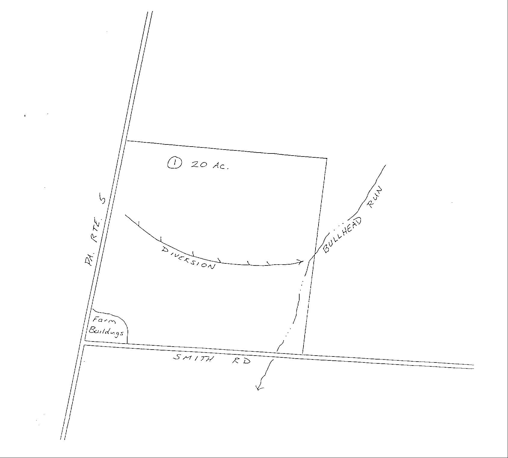
SAMPLE CONSERVATION PLAN
PLAN MAP
John Smith, Owner Bill Jones, Operator
Sketch, Approximate Scale, 1"=400’
SAMPLE CONSERVATION PLAN
SOILS MAP
John Smith, Owner Bill Jones, Operator
The farm boundaries may be added to a copy of a published County Soil Survey Map. Information from the soil survey report that describes the soils limitations (steep slope, poor fertility, poor drainage, etc.) would be added to the map or included as additional pages.
SAMPLE CONSERVATION PLAN
CONSERVATION PLAN NARRATIVE
John Smith, Owner Bill Jones, Operator
Approx. Date Practice
Field Amount Planned Name and Description
1 1500 ft. Apr 1997 Diversion: Will be installed where shown on plan map to divert runoff water from cropland: to be maintained in permanent grass sod.
1 20 ac. May 1997 Contour Farming: Crops will be planted parallel to diversion or along established contour lines.
1 10 ac. Oct 1997 Cover Crop: Rye will be planted to provide temporary ground cover over winter when crop residue or fodder is removed.
1 20 ac June 1998 Conservation Crop Rotation: Will use a rotation no more intensive than three years of corn followed by at least three years of grass or grass-legume hay. The first year of hay should be planted by the date planned. If corn is harvested as silage, a cover crop will be used as described.
1 20 ac June 1998 Nutrient Management: Nutrients applied from all sources (manure, fertilizer, legumes, etc.) will not exceed amounts removed by crops over the life of the planned rotation.
All conservation practices will be designed, operated, and maintained according to criteria in the Pennsylvania Soil and Water Conservation Technical Guide