 |
Delineation of contributing areas for surface water is more straightforward than for groundwater. EPA (1997) has identified three primary methods for source water protection area (SWPA) delineation:
- Topographic boundary delineation (watershed)
- Buffer zone/setback
- Time-of-travel calculation
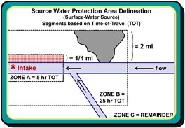
Pennsylvania also employs a three-tiered approach to SWPA’s for surface water sources and is modeled after that used by the Ohio River Valley Sanitation Commission (ORSANCO). Zone A is a 1/4 mile buffer on either side of the river or stream extending from the area 1/4 mile downstream of the intake upstream to the five hour time-of-travel (TOT). Zone B is a two-mile buffer on either side of the water body extending from the area 1/4 mile downstream of the intake upstream to the 25 hour TOT. Zone C constitutes the remainder of the basin. The illustration shows the approach.
Illustration: Three-tiered approach to SWPA delineation for large drainage basin used by surface-water source.